|
Handbook of Jamaica This Digital Handbook
of
Jamaica is a special online
publication by the National Library of
Jamaica (NLJ) similar to the now out of print Handbook of Jamaica. It
provides information about various aspects of the country’s existence and
development. Through brief descriptions and links to institutions and
organizations, it guides users on where to find relevant information about
Jamaica’s: Population and Vital Statistics Education (To be added) Sports (To be added) Arts and
Entertainment (To be added) Institutions
and Organizations(To be added) Communication
and Transportations(To be added) Religion(To be added) Miscellaneous
Information(To be added) Physical Description
Historical
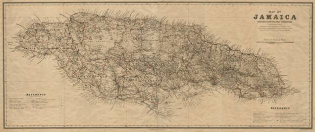
Map of Jamaica
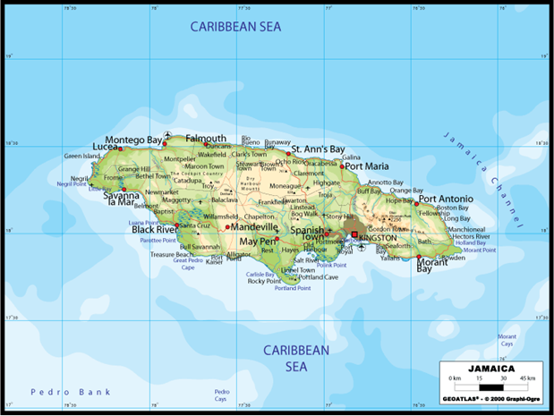
Current
Map of Jamaica Climate Jamaica is the third
largest island of the Greater Antilles and it is surrounded by the Caribbean
Sea. Lying about 90 miles south of Cuba, it is located at an estimated
latitude 180 N and longitude 770 W. Its climatic conditions are usually described
as tropical, hot, humid, and temperate interior; these are sometimes affected
by weather systems such as troughs, cold fronts and upper and low-level
low-pressure centres. Other weather systems common
to the island include: Tropical Waves, Tropical Depressions, Tropical Storms,
and Hurricanes which generally develop between June and November, a period
that is officially referred to as the hurricane season. Weather and climatic
conditions are monitored by the Meteorological Office of Jamaica. Rivers There are a number of
rivers in Jamaica, most of which emanate in the central mountainous region of
the island. They usually flow at a relatively
high speed and several of them contain rapids (falls). Rivers that flow south
are usually of more length than those which flow north. Rivers that flow south include: Plantain Garden - flows from the
Blue Mountains; Yallahs River - flows from Silver
Hill Peak; Hope River - emerges close to New Castle; Rio Pedro - flows from
Above Rocks; Rio Minho - emerges near Spalding; Milk River - flows from Porus.
Among the rivers which flow
north are: Rio Grande - rises in the Blue Mountain; Wag Water - rises in
the Blue Mountain; White River - emerges near Guys Hill, St. Mary; Martha
Brae - rises near Windsor, Trelawny; Montego River - emerges in central St.
James; Great River - flows from St. Elizabeth.
Main
Rivers of Jamaica by Length and Parish (Statistical Yearbook of Jamaica 1999) Mountains These
are a prominent part of the island’s surface, especially in the eastern
sections. Blue
Mountain Peak (2,256 metres),
which is the highest of all, for instance is located at the eastern end of
the island. While the main line of mountains leads off from an easterly to
westerly direction. Though the mineral content of the mountains are varied,
the dominant mineral is limestone.
Parish
and Height of Major Mountains in Jamaica(Statistical Yearbook of Jamaica
1999) Caves
These are common to
the island, particularly in the limestone areas. They usually penetrate the
limestone formation in different directions. Among these caves are: Abbey Cave in
Hatfield, Manchester; Arlington Cave in Arlington, St. Catherine; Green Grotto Caves in Salem,
St. Ann; Negril Light Cave in Negril,
Westmoreland; Rejoin Cave in Rejoin, Hanover; White Cave in New Hope,
Trelawny; Wallingford Main Cave in Balaclava, St. Elizabeth; Ferry Cave in
Ferry River, St. Andrew, Banana River Cave in Banana River, St. Thomas, Barry
Cave in Welcome Hall, St. James, and White Goat Cave in Jackson’s Bay,
Clarendon. Beaches:
Jamaica has many beaches extending from Negril
Point in the west to Portland in the east. Some public beaches are
administered by the Urban Development Corporation. Popular Jamaican beaches
include: ·
7 Miles Beach in Negril Westmoreland ·
Ocho
Rios Beach ·
Fort Clarence and Hellshire in St. Catherine ·
Long Bay Beach in Negril, Westmoreland ·
Doctors’ Cave Beach in Montego
bay, St. James ·
Puerto Seco
Beach in Discovery Bay, St. Ann ·
San San
Beach in Port Antonio, Portland ·
Dunns River
Beach in Ocho Rios, St. Ann ·
Bluefields
Beach in Bluefields, Westmoreland ·
Treasure Beach in St. Elizabeth ·
Prospect Beach in St. Thomas ·
French Man’s Cove ·
James Bond Beach in St. Mary Population and Vital Statistics Ethnic
Composition Jamaica has a diverse population which mainly
comprises people of African, Indian, Chinese, European, and Middle Eastern
descent, the greater proportion is of African descent. Demographic
and Vital Statistics The primary entities
responsible for disseminating and gathering statistical information relating
to the islands population and vital statistics (births, deaths, etc.) are the
Statistical Institute of Jamaica and
the Registrar’s Generals Department. A
census is done every ten years, the last population census was conducted in
2011 (2011 census); it includes data on
housing, population distribution by age, educational attainment by gender,
etc.
Population Usually Resident in
Jamaica, by Parish: Census 2011 Early
Inhabitants Jamaica has a very
rich history, which is the foundation or roots of what may be described as
the island’s diverse ethnic composition
and by extension culture. The starting point of this history is often marked
by the Spanish’s capture (led by Christopher Columbus) of the island in 1494.
Until their arrival, Jamaica’s native population comprised mostly, if not
entirely Tainos. As a result of their decimation by
the Spaniards among other reasons, there exists little historical recordings
on the Tainos, and most of what speaks to their way
of life is artefacts and archaeological findings. English
Colonization The Spanish ruled the island for over a
century, leaving their mark on its history in different ways, but
incomparable to that of the English who took the island (under commanders Vennables and Penn) from them in 1655. This is one of the
major turning points in Jamaica’s history as the English would rule the
island for a little over three centuries. There are several events or
occurrences that were induced by the English’s rule, which not only explains,
but has also, shaped Jamaica’s history. The
Slave Trade and African Enslavement Above all, the Slave
Trade and the enslavement of Africans have left indelible marks on the
historical landscape of Jamaica. Emancipation
In the year 1838, 31
years after the slave trade ended, full freedom was declared in the British
West Indies. Emancipation was the dawn of a new era in Jamaica’s life. Independence Jamaica acquired independence from Britain on the 6th
of August 1962. The 1938 labour rebellions and
resulting labour/ trade unions, the formation of
the People’s National Party (PNP) and Jamaica Labour
Party (JLP), the campaign for universal adult, the push for self government,
and universal adult suffrage were all important factors that galvanised the Independence cause. Norman Manley and
Alexander Bustamante, often referred to as fathers of the nation, played very
critical roles in the attainment of Independence. They were the most
prominent political leaders who led the campaign. Jamaica’s new status, Independence, translated
into it being an autonomous state, completely responsible for its social,
economic, and political relations. Among the changes that resulted from this
status were: the creation of a new constitution, army, currency, symbols and
emblems, and passport. Jamaica’s Independence is a national holiday and is
celebrated annually on the 6th August. Some of the primary
agencies responsible for the preservation and articulation of Jamaica’s
history include:
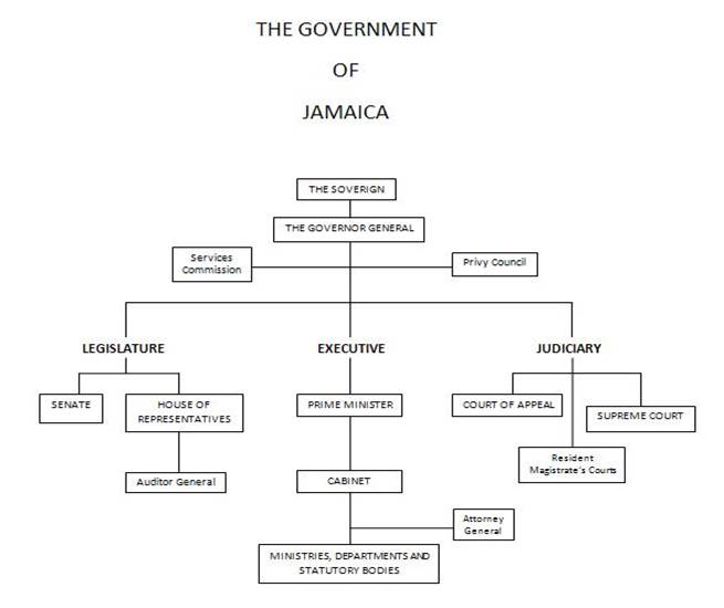
Jamaica is a Constitutional Monarchy and has at its head the Queen of England, who is represented by the Governor General. Nonetheless, the style of governance which the country employs is Parliamentary Democracy.
Jamaica’s
Parliament is bicameral, having an Upper and
Lower House, which is also referred to as the Senate and House of
Representatives respectively. While the members of the House of
Representatives are elected under universal adult suffrage the Senate is
appointed by the Governor General on the advice of the Prime Minister and the
Opposition Leader. The House of Representatives consists sixty three members
which is equivalent to the same number of constituencies, while the senate
has twenty one, thirteen chosen by the Prime Minister and eight by the Leader
of Opposition. Jamaica’s parliamentary house, named Gordon House in honour of
National Hero George William Gordon, is located at 81 Duke Street, Kingston.
Parliamentary publication, such as Acts, Green Papers, speeches, minutes and
general reports can be found on the Houses of Parliament website. The
Cabinet: is the chief body that formulates and executes
government policy. Members of the Cabinet are elected as well as nominated
Ministers of the ruling party. More
on the Cabinet Ministries
There are sixteen
(16) ministries:
Legal System Jamaica
employs the ‘Common Law’ legal system (see
Supreme Court website for more information). This system is
a legacy of English rule of the island. It is dictated by social customs and
norms, and upheld and enforced by the courts. According to this legal
framework, all members of the society, regardless of their social position,
are subjected to the same set of laws and the power of government is checked
by such laws. Judicial System The
judicial system of Jamaica comprises five (5) basic tiers: the Privy Council;
Court of Appeal; Supreme Court; Resident Magistrates’’ Court; and Petty
Sessions Court. These courts are the official and legal bodies commissioned
to address issues of different natures and levels. They are usually named
according to a particular classification of issues such as: traffic, family,
Coroner, gun, and revenue. The Ministry of Justice
is the lead administrator of Justice in Jamaica and therefore administers legislation, delivers justice
services, and provides policy support and analysis on justice issues. Jamaica’s economy is
managed by the Ministry of Finance and Planning. It is mandated to develop
the Government’s fiscal and economic policy framework; collect and allocate
public revenues and facilitate the socio-economic development of the country.
Jamaica employs a liberal economic system; however, there is some amount of
restrictions on areas such as finance, trade and investment. Both short and
long terms formal regional and international liberal economic agreements
which the country has signed on to include: the Caribbean Single Market and Economy (CSME),
Economic Partnership Agreement (EPA) with the European Union, and the Major
Infrastructure Development Programme (MIDP) with
China. Finance
and Banking The financial sector
of Jamaica is regulated by the Bank of Jamaica
(BOJ), Jamaica’s central bank. Its purpose is to “formulate and implement monetary and
regulatory policies to safeguard the value of the domestic currency
and to ensure the soundness and development of the financial system
by being a strong and efficient organization.” Trade
& Investment The Ministry of Investment Industry and Commerce
is the arm of government that oversees the country’s investment and trading relations.
However, there are two subordinate entities that manage the country’s trading
and investment activities, The
Trade Board of Jamaica (TBJ) and Jamaica
Promotions Corporation (JAMPRO). The Trade Board of Jamaica
serves as the “national focal point
for support of modern commerce through trade regulation and being a
repository for and disseminator of national, regional and international trade-related
information.” While Jamaica Promotions Corporation, “is the Government Agency
mandated to promote and facilitate trade, investments and promotions and to
encourage and support the export of Jamaican products.” |